
April 1, 2015by #bushireTags: Australia, Bus Hire, The Blue Mountains
7 Easy Blue Mountains Family Treks with Bus Hire Options
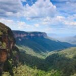
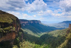
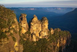
You would be surprised to find out the diversity of touristic attractions that exist at the blue mountains Australia. From the stunning 3 sisters foundations to some of the most beautiful waterfalls in the entire continent, there’s no lack of activities to keep you and your travel companions, whether your family or friends, occupied and constantly wondering at the natural beauty surrounding you.
If there’s one thing we have noticed after organizing trips country wide for our customer, is that, when it comes to the Blue Mountains, trekking is by far one of the most preferred activities. We also noticed many parents with children were constantly (and rightfully) concerned whether trekking certain paths could be dangerous. We wanted to create a resource that would help those holiday planners, who are also trying to find the best tracks to explore together with their kids, save time when trying to decide which locality will be better suited to visit because of the easy tracks offered there.
Let’s analyze some of the most popular and well known tracks that have kept adventurers busily walking through the wonderful lush beauty of the Blue Mountains right here in New South Wales. Do remember to contact us in case you need any assistance arranging your transport, we have a huge fleet of minibuses and coaches ready to provide you with what you need, and we love answering your questions too, so send them over!
In the mean time, here’s where you should go when trekking the Blue Mountains with your kids:
Lapstone Zig Zag/Knapsack Gully Viaduct:
Approximate walking time: 1 hr
What makes this track particularly easy is that is set along the old railroad tracks. The old rail tracks will take you and your exploring family to the old Gully Viaduct, which was the biggest one in Australia (and used by all motor vehicles) until; it was bypassed in the mid 1990s. Today only pedestrians and bicyclists populate it.
Lapstone Zig Zag Railway trekking path Australia - Google My Maps
Open full screen to view more
Lapstone Zig Zag Railway trekking path Australia
Collapse map legend
Map details
Copy map
Print map
Zoom to viewport
Embed map
Download KML
View map in Google Earth
1,898 views
Published on March 11, 2016
Lapstone Zig Zag Railway
![]()
Lapstone Zig Zag Railway
Made with Google My Maps
No results
Search this map
Move map to
From your map
From Google
| | | | --- | --- | | `←` | Move left | | `→` | Move right | | `↑` | Move up | | `↓` | Move down | | `+` | Zoom in | | `-` | Zoom out | | `Home` | Jump left by 75% | | `End` | Jump right by 75% | | `Page Up` | Jump up by 75% | | `Page Down` | Jump down by 75% |
![]()

Keyboard shortcuts
Map DataMap data ©2026 Imagery ©2026 Airbus, CNES / Airbus, Maxar Technologies, Vexcel Imaging US, Inc.
Map data ©2026 Imagery ©2026 Airbus, CNES / Airbus, Maxar Technologies, Vexcel Imaging US, Inc.
50 m
Click to toggle between metric and imperial units
Share via Facebook
Share via Twitter
Share via email
Embed on my site
Sign in
Lapstone Zig Zag Railway trekking path Australia
AboutThis map was made with Google My Maps. Create your own.
1,898 views
Made with Google My Maps
Lapstone Zig Zag Railway trekking path Australia
- Map data ©2026 Imagery ©2026 Airbus, CNES / Airbus, Maxar Technologies, Vexcel Imaging US, Inc.
- Terms
200 ft
This map was created by a user. Learn how to create your own.
Manage account
Create new map
Open map
Shared with you
Help
Feedback
Report inappropriate content
Report abusive content
Report legal issue
Google Drive
Nat. Park Glenbrook Entrance/Euroka Picnic Area:
Approx walking time: 3 hrs
Starting right at the entrance of the Glenbrook national park, this trail has very well kept and straight paths, so you will not have to worry about rugged or difficult terrain. It extends from the entrance of the park to one of the main camping stations at Euroka area.
Trekkers will enjoy natural trails that go right through the lush green vegetation of this picturesque national park in the Blue Mountains Range.
National Park entrance Euroka Picnic trekking route - Google My Maps
Open full screen to view more
National Park entrance Euroka Picnic trekking route
Collapse map legend
Map details
Copy map
Print map
Zoom to viewport
Embed map
Download KML
View map in Google Earth
1,852 views
Published on March 22, 2016
Untitled layer
![]()
National Park Tourists Centre
![]()
Euroka Campground
Directions from National Park Tourists Centre to Euroka Campground
National Park Tourists Centre
Euroka Campground
Made with Google My Maps
No results
Search this map
Move map to
From your map
From Google
| | | | --- | --- | | `←` | Move left | | `→` | Move right | | `↑` | Move up | | `↓` | Move down | | `+` | Zoom in | | `-` | Zoom out | | `Home` | Jump left by 75% | | `End` | Jump right by 75% | | `Page Up` | Jump up by 75% | | `Page Down` | Jump down by 75% |
![]()
![]()


Keyboard shortcuts
Map DataMap data ©2026 Google
Map data ©2026 Google
5 km
Click to toggle between metric and imperial units
Share via Facebook
Share via Twitter
Share via email
Embed on my site
Sign in
National Park entrance Euroka Picnic trekking route
AboutThis map was made with Google My Maps. Create your own.
1,852 views
Made with Google My Maps
National Park entrance Euroka Picnic trekking route
- Map data ©2026 Google
- Terms
2 mi
This map was created by a user. Learn how to create your own.
Manage account
Create new map
Open map
Shared with you
Help
Feedback
Report inappropriate content
Report abusive content
Report legal issue
Google Drive
Madoline Glen/Birdwood Gully
1.5 hr
Sassafras Gully / Victory Track / Faulconbridge
4hr
Certainly the longest trek on our list, this track should take you from the reserve at the Sassafras Gully, along the Victory Track right up to the Faoulconbridge where you will get the chance to witness stunning views of the valley below. It’s certainly worth the near 4 hours of walking time, possibly not best suited for the smallest kids.
Sassafras Gully Reserve to Faulcon bridge trekk - Google My Maps
Open full screen to view more
Sassafras Gully Reserve to Faulcon bridge trekk
Collapse map legend
Map details
Copy map
Print map
Zoom to viewport
Embed map
Download KML
View map in Google Earth
1,657 views
Published on September 23, 2016
Untitled layer
![]()
Sassafras Gully Reserve
![]()
Faulconbridge
Made with Google My Maps
No results
Search this map
Move map to
From your map
From Google
| | | | --- | --- | | `←` | Move left | | `→` | Move right | | `↑` | Move up | | `↓` | Move down | | `+` | Zoom in | | `-` | Zoom out | | `Home` | Jump left by 75% | | `End` | Jump right by 75% | | `Page Up` | Jump up by 75% | | `Page Down` | Jump down by 75% |
![]()
![]()


Keyboard shortcuts
Map DataMap data ©2026 Google
Map data ©2026 Google
10 km
Click to toggle between metric and imperial units
Share via Facebook
Share via Twitter
Share via email
Embed on my site
Sign in
Sassafras Gully Reserve to Faulcon bridge trekk
AboutThis map was made with Google My Maps. Create your own.
1,657 views
Made with Google My Maps
Sassafras Gully Reserve to Faulcon bridge trekk
- Map data ©2026 Google
- Terms
5 mi
This map was created by a user. Learn how to create your own.
Manage account
Create new map
Open map
Shared with you
Help
Feedback
Report inappropriate content
Report abusive content
Report legal issue
Google Drive
Conclusion:
Even though sometimes we fail to identify trekking as a family friendly activity, these easy track should be straightforward enough to seed the love for trekking into your kid’s hearts without pushing them into exhaustion. Though all of the routes we talked about are rather easy in regards to their danger level, many of them are still quite long, factor you should consider before embarking in a 4 hours ordeal.


